


Post by SKYSUMMIT on Oct 4, 2023 18:11:53 GMT -6
Meanwhile in Texas:
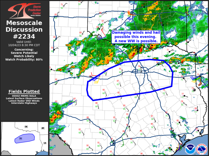
Mesoscale Discussion 2234
NWS Storm Prediction Center Norman OK
0702 PM CDT Wed Oct 04 2023
Areas affected...portions of central TX
Concerning...Severe potential...Watch likely
Valid 050002Z - 050130Z
Probability of Watch Issuance...80 percent
SUMMARY...Several cluster of storms including a few supercells
should continue east/southeast with a risk for damaging winds and
hail. A new WW or local extensions of existing watches are being
considered.
DISCUSSION...Across portions of north-central TX, ongoing convection
has slowly grown upscale into a few, more defined clusters over the
last couple of hours. Previous storms over OK and north TX have
pushed an effective outflow boundary south of the Red River to just
north of I-20. Along and south of the boundary, the air mass remains
quite unstable (1500-2000 J/kg) of MLCAPE owing to the upper 60s to
low 70s F surface dewpoints. Area VADs also show the air mass
remains moderately sheared, sufficient for organized severe storms.
Given the recent upscale growth trends, further growth of the
clusters is expected with time. Damaging winds appear to be the most
likely severe threat given the potential for strong updrafts and the
more linear structures. However, with some potential for supercells
and the moderate buoyancy, isolated hail will also remain possible.
The greatest severe risk appears to be focused along the I-20
corridor through the next several hours, though storms may
eventually take on a more southeastward motion as outflow
consolidates. Given the relatively pristine air mass ahead of the
ongoing storms, severe potential should increase this evening. A new
WW and/or extensions of the existing watches are being considered.
..Lyons/Guyer.. 10/05/2023


